Bijindo – A hint of Thailand in Korea

Bijindo is an island just south of South Korea.  After enjoying a sunrise hike in Hwangmaesan we took the ferry from Tongyeong Ferry Terminal to Bejin Island (do means island in Korean).  The 40 minute trip went quickly as sea spray and fresh air came over the sides of the boat while a few seagulls entertained us by trailing behind and snatching chips out of the sky!

_DSC6796 Bijindo 5

Once on Bijindo it was easy to find our pension.  The whole island only has a few hundred people living on it in one small village and another smaller beach-side hamlet.  From afar it is easy to confuse Bijindo with one of Thailand’s many tropical paradises.

_DSC6939

_DSC6989 _DSC6831

Continue reading

In the Shadow of Mount Olympus – Hurricane Ridge

Waking up in a rainforest is an experience that should be on everyone’s bucket list.  The pristine sounds of nature trickling through the canopy are a soothing alarm clock as the sun rises in the east.  My brother and I crawled out of our tent to birds chirping and dew glistening on blades of grass as rays of light shone through the pines.  We broke our fast with some oatmeal and quickly followed by breaking camp.  Today we would be driving further into and around Olympic National park to one of the premier views, Hurricane Ridge.

29-_DSC3746.NEF01-1-_DSC3773.NEFa

02-_DSC3864a

Walking to our car we passed an old phone booth, perhaps left as a reminder that our cell phones might not penetrate this deep into nature’s beauty.  We piled into the car and took the scenic drive out of the Hoh Rainforest.  Leaving the forest I couldn’t help but notice the trees are still green and beautiful but thin out as quickly as the nostalgia for massive redwoods sets in.  The best cure is to look forward to the next adventure!  We followed the Olympic Highway skirting the park with a few scenic stops along the way.  The first was at the beautiful, glacial Lake Crescent.  These icy waters were refilled with this years’ spring melt; although the 600 ft deep fissure was carved millions of years ago by a glacier taller than the towering peaks above.  A few more curves through the mountains and we could see Port Angeles; we took a quick gas stop and started our way back into the park.  The 17 mile drive up mountain roads was a gamble; we knew the road was open but my brother had been to the top a few times only to have the clouds roll in front of Mt. Olympus.

03-14-_DSC0144a

We followed the 2 lane road as it wound around and through the mountain in tunnels blasted into the rock.  Suddenly we saw brake lights ahead, luckily it was only construction.  We waited patiently for the single lane to open in our direction but before we knew it the orange flag waved us through.  My gaze veered to the clouds above the evergreens on our left, hiding all of the magnificent peaks. My brother insisted that I shouldn’t worry as these clouds were too low to matter when our drive came to a crawl yet again.  This time fog surrounded us just before we entered the next tunnel.  Bursting out of the passage we found even more mist; there was a magical sense to it all which was only enhanced by the tiny Christmas trees lining the guardrail.  I quickly realized that we were staring at the tops of massive evergreens growing on the cliffs below.  All of the sudden we came through the clouds with blue skies above!  Before us lay a peaceful panorama of glorious green hills above a sea of white fluff with the snow-capped peaks in the distance.

04-15-_DSC0145a

We took a quick stop at the next overlook to dance among the treetops.  The cool mountain air was a refreshing break from the recirculated cabin of our car.  Following a short path we quickly found the edge and stared down into the mists below.  A massive raven erupted out of the white veil; skimming the treeline the beast let out a shrill cry before diving back beneath the clouds.  My brother informed me that the illustrious Hurricane Ridge wasn’t much further.  Crossing our fingers as we got back into the car, we made a silent prayer that the Olympic Mountains would be as clear as the info panel’s picture.

05-16-_DSC0151

06-_DSC3880

Another mile up the road leveled off.  Hiding at the edge of this rounded bluff was the Hurricane Ridge visitor center.  We parked, stretched and were ecstatic to find the only clouds in sight high above in the stratosphere.  Mt. Olympus stood above its stoic brethren at 7,980 feet.  Just to the left of the massive mountain we could clearly see the beautiful Blue Glacier; its icy sisters now a distant memory.

08-18-_DSC0158a

19-_DSC0160a

It is a wonder to think that only yesterday we were far beneath that ridge hiking through the bountiful rainforest.  After a brief photo op we took the short hike to view the northern ridge behind us.  Sadly it had lost its white wisps in the summer sun. Drawing ourselves closer to the edge we peered down to the cloud cover in the valley below.  I figured the evergreens on our hilltop continued all the way beneath the clouds but was quickly informed that I was in fact peering into another country.  On a clear day you could see the far shore of Canada’s Strait of Juan de Fuca.

13-_DSC3881a  20-_DSC3888a

Walking the rest of the paved loop lined with evergreens and wildflowers, we made our way back to the visitors center.  There, we found a ranger leading a discussion about forest fires and the havoc they could wreak.  He quickly consoled a naturalist in the crowd reminding everyone that nature was resilient.  In fact, there had been a number of blazes over the years; evidence of which were covered up by a thick forest of conifers that fed on the nutrients which fell beneath the ashes.  I took a moment for one last photo with this amazing panorama before my brother reminded me that I had a plane to catch.  A few more hours on the road and we said our goodbyes before I flew back to the East Coast.

22-_DSC3890.NEFa

Read about the first day in Olympic National Park here!

In the Shadow of Mount Olympus – The Hoh Rainforest

When most people hear rainforest they immediately think of a tropical one, perhaps The Amazon, in Costa Rica or a tropical island.  It turns out a rainforest is based on how much precipitation falls and has nothing to do with proximity to the tropics.  I know crazy, right?  There are in fact tropical rainforests like most people think and temperate rainforests such as the Hoh Rainforest at the base of Mt. Olympus.  In the Hoh between 12 and 14 feet of precipitation fall each year, making it one of the wettest places in the US!

Precipitiation chart

I flew into Seattle and with a quick stop at my brother’s apartment to make my luggage a little more “camping-friendly” we were off.  We promptly got caught up on brotherly things and began discussing our upcoming adventure.  The plan was to head to Olympic National Park where we could camp near the Hoh Rainforest Visitor Center, enjoy a few hikes and then head to Hurricane Ridge.  Driving along the coast we stopped at many scenic overlooks as the dense forests worked their way up to the Pacific.  A quick trail from the highway took us down to the beach.  Walking between malformed trees you could taste the salty air as the waves grew louder.  Instantly the path opened up to a marvelous view of the ocean and a beach strewn with massive white driftwood; a firm testament to the ocean’s strength.

23-_DSC3713

24-_DSC3716.NEF

25-_DSC3722.NEF22-_DSC3709.NEF

Our next stop took us to the first of many tremendous trees.  We learned that the world’s largest spruce tree is a whopping 191 feet tall and nearly 59 feet across it.  That means it would take 10 people to give this guy a proper tree hug!  A quick photo op, some more rock albums, a vampire-free drive through Forks, WA and we came upon the Hoh Rainforest Visitor Center.  After setting up camp we took a stroll down the Hall of Mosses sporting a river that shone like emeralds and moss covered trees.

27-_DSC3737.NEF

_DSC0034a26-_DSC3733.NEF

Envisioning moss monsters and treants lumbering down the path I came to the subtle realization at how peaceful it was.  Immediately I knew that these would certainly be benevolent creatures if this were in deed the fantasy world it seemed to be.  The trail continued a few miles before the loop brought us back to our campsite.  We ate a hearty dinner to prepare for a full day of hiking in the the heart of the Hoh!

46-_DSC3867

We rose early, hoping to get on the trail before the heat of the sun.  It was a quick walk to the visitor’s center where the Hall of Moses met with the Hoh River Trail.  Along the way we saw postings letting us know that we were entering “cougar country”, no not that kind of cougar, the dangerous wild cat that could tear you to shreds.  A quick read informed us that sitings were in quite rare and gave us a few tips just in case.  As we started down the Hoh River Trail we realized that the Hall of Mosses was merely the tip of the iceberg in this magnificent rainforest.

28-_DSC3740.NEF

04-_DSC0075

31-_DSC3755

At first the path was accented by logs and planks clearly placed by park rangers.  There were regular footbridges to help cross streams and gulleys.  Every tree in sight was covered with hanging mosses making the greenery shine like an emerald.  The forest floor was filled with all kinds of plant life, everything from ferns to clover with shrubberies in between.  A variety of fungi could be found wherever a dead tree lay; mostly massive mushrooms, we didn’t dare find out if they were edible.

29-_DSC3746.NEF

43-_DSC3849

30-_DSC3752

22-_DSC3770.NEF

We came across minimal wildlife, scaring a green snake, it slunk away before I could snap a picture.  Insects on the other hand were everywhere; mosquitoes erupted near muddy patches in the trail and gargantuan black slugs were never far from decaying trees.  The path was well trodden and we passed a handful of hikers but the man-made bridges were no more.  We crossed the next stream using a downed tree as we traversed deeper into the Hoh; the serenity of nature continued to grow.

33-_DSC3759.NEF

32-_DSC3757

36-_DSC3777

A humongous tree had fallen across the path with a section carved out for safe passage.  The tree so large that the crack running up its core was more than enough room to take a nap.  Before long we heard the distant sound of rushing water.  Sure enough there was a beautiful waterfall feeding the stream that crossed our path.

37-_DSC3787

42-_DSC3847.NEF

13-_DSC0137

Near the gushing water stood a huckleberry bush; a passing traveler mentioned that they were delicious and we decided to try a few.  They were juicy and full of flavor; too bad he picked most of the ones on this trail.  Just ahead a grove of towering redwoods made for some excellent climbing before we continued on.

03-_DSC0074

11-_DSC0129

06-_DSC0080
05-_DSC0076

The rushing water grew louder; perhaps it wasn’t the waterfall we heard but the enormous Hoh River that the trail was following.  As we rounded the next bend there it was before us.  A massive waterway bringing glacial flow to the valley showed its power with uprooted trees, now white with decay.  Under the shade of an enormous oak we broke for lunch within view of the river.

40-_DSC3832

34-_DSC3763

41-_DSC3842

44-_DSC3852.NEFThe sun already coming back down in the afternoon we decided to go a few more miles before heading back to camp.  Coming across even more moss laden trees and incredible greenery we passed the Happy Four Campsites.  If we didn’t have plans for Hurricane Ridge tomorrow perhaps we would have stayed the night.  With our shadows growing longer we reluctantly began retracing our steps.  Our trip into the Hoh proved as magical as we had hoped, witnessing the beauty that nature can produce when left to its own devices.

02-_DSC0070

_DSC0135a

07-_DSC0087

Read about the next day in Olympic National Park here!

A southwest journey to find True North – Zion National Park, Day 7

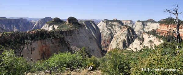
We woke up for our last day of backpacking full of excitement!  Just a few miles on the West Rim Trail before we would reach Angel’s Landing, one of the main reasons we picked this route.  After breakfast we took a water count, decided that we had enough to make it to Angel’s Landing and got moving.  Retracing last night’s water run, we found the same splendor now with morning sun illuminating green valleys and floating forests.  The magnificence of Zion continued with marvelous white rocks streaked with reds and greys.  Trees littered the hills providing a spectacular green contrast to the sun-bleached rock.

1-071-_DSC0853

1-072-_DSC0858

077-_DSC0875

079-_DSC0881Down the next hill we walked through a scattered forest of green pines.  The shade it provided was much appreciated and we took a pack break at the fork.  To the left lay the spring that saved us last night, to the right, new territory that drove us deeper into the canyon.  We were all confident from the last 2 miles that we had enough water for the final leg.  I shimmied up two trees for a better view and shortly after we were off.  The path was full of steep switchbacks carved into the massive rock.  The wooded valleys creating a beautiful panorama that grew closer with each step.  We continued on, hoping that the path led through the forest rather than up the next mountain.

1-_DSC0913b

084-_DSC0938

085-_DSC0946

1-088-_DSC0982As we rounded the next switchback we passed our first sign that we weren’t alone, a trail runner charging up the mountain we had just come down.  A few switchbacks later a group of boys with massive ropes, helmets and plenty of carabiners were slowly ascending.  These mountaineers were climbing the path seeking the thrill of a much faster trip down.  Perhaps on my next trek through Zion I’ll look into rappelling, for now I was content with backpacking.  The resilience of nature was present at every bend with trees growing out of each crag.  Anywhere greenery could get a foothold it took root and somehow flourished in this desert paradise.  At the next switchback I found a perfect backdrop, but my models quickly lost interest as I took too long to get the lighting just right.  Surfing our way down, we quickly came to the valley below with a stunning view of the cliff, which only moments earlier, we were gazing down from.

089-_DSC0986

087-_DSC0979

093-_DSC0996

090-_DSC0988

092-_DSC0994The trail flattened out in the valley as our prayers were answered, looping into the forest as we rounded the perilous mountain.  We took a wrong turn, sure that we had to climb up the mountain and quickly lost the trail among the natural steps in this beautiful grey masterpiece.  Calling ahead for the rest of our group to no avail, we turned around and retraced our steps until we could discern the trail.  “Over here,” I heard a cry, our misadventure was but a small blip on this journey.  Around the bend we found the rest of our group enjoying the shade of a looming conifer as the sun drew itself high in the sky.  We joined them for a few moments and promptly continued to the other side of the giant bluff.

094-_DSC1008

098-_DSC1017

097-_DSC1016

096-_DSC1013We were saved from one climb, but the next loomed ahead as the incline grew steeper.   Up and up we went with each switchback; alternating red and white trails layered with evidence of the ancient erosion that carved the natural beauty out of solid rock.  We paused momentarily to feel how smooth these red, white and now yellow rocks had become through eons of wind and rain.  The trail grew higher still as we finally rounded the corner to the peak of our current endeavor.  What a view, glancing around we were nearly as high as the stoic red and white guardians surrounding Zion Canyon.  In the distance loomed our next mission, Angel’s Landing!

104-_DSC1058a

101-_DSC1044a

099-_DSC1020

100-_DSC1041

Stunned by the picturesque scene before us, we paused under the heat of midday to take in the beauty and some of the glorious water that remained.  Our group once again strewn across the trail like leaves scattered in the wind.  We could make out a few down the trail from us; looking more like squirrels in the forested backdrop than the friends we had recently made.  Continuing down the trail Angel’s Landing inched closer.  The realization of just how strenuous the climb would be soon hit us as the butterflies of vertigo swam back into my core.  I could do it; I will persevere!

102-_DSC1046

103-_DSC1055a110-_DSC1086

We quickly came upon Scout’s Lookout, a staging area for the final ascent and turnaround for small children, the elderly and others too weak to continue.  We found part of our group resting in the shade.  Had they decided to skip this spectacular climb?  It turns out they were low on water and the group split up; half going ahead to find the next water source while the others waited for us with the gear.  The comedy of errors that ensued began with us skipping this morning’s spring and split our group into 3 attempts at Angel’s Landing.  The water caravan had gone down Walter’s Wiggles (a series of 21 steep switchbacks) to a river nearly 2 miles away.  Part of the group found a spring and began to filter water while the others went to find a second source.  They accidentally left the filter and carried “dirty” water back to be filtered later.  I was oblivious to most of this since the first 2 liters came back with 2 winded hikers.  Tired from their journey they insisted that 3 of us head to the top with fresh water while some rested and others went out to search for the missing crew.  I obliged.  2 liters of water, 2 fabulous females, a camera and I began scaling this monstrosity.112-_DSC1088

114-_DSC1091

We had little time to reflect back on our decision to leave everyone behind, as the route proved treacherous.  A sign at the beginning informed us that six had taken a fatal fall over the past decade; you better believe we were going to use the reinforced chains along our climb.  The journey turned out to be a series of small hikes along smooth steps cut into the rock with a sheer cliff on either side.  In between these short hikes were difficult climbs up boulders and even steeper steps with the occasional level stretch for some respite.  On occasion I peered over the edge to get a glimpse at the forested canyon a dizzying 1400 feet below.

117-_DSC1097a 115-_DSC1094aWorking our way up we passed many other travelers, often pressing our bodies flat against the rock to allow others to come down while we continued our ascent.  The view around bend continued to amaze; each set of chains taking us higher and higher.  In the distance we could see the summit but for now we took a water break.  Putting the 1-liter bottle back in my pocket I resumed my climb, dodging trees and boulders as I tried to keep myself as close to the center as possible.  One misstep and it could be a much quicker descent than planned.  Briefly looking back on our path it was easy to see we had already reached a significant height above Scout’s Lookout.  As I turned back around my water bottle brushed the rock and came loose, bouncing a few times before it rolled the final 10 feet towards the cliff and disappeared into the void.

128-_DSC1164a121-_DSC1109a

I stood there a moment in disbelief, and quickly realized how glad I was that it was only a water bottle and not something more valuable.  The trail grew narrower as it leveled off creating a thin rock bridge connecting us to the final peak.  One massive chain along the bridge led us to a solitary tree, the next chain loomed just below and out of reach.  A sloping, smooth rock between us.  In the shade of that pine one of our companions decided she had enough and clung to the tree declaring herself a sentry for the rest of our group.  Down to two of us, we continued across the bridge to the ultimate ascent.

118-_DSC1103a116-_DSC1095

120-_DSC1106

The series of massive steps were accompanied by even more chains as the climb proved quite vertical.  One after another we continued up, pausing only briefly to let someone journey downward.  As we came to an especially steep switchback I paused to catch my breath and take in the scenery.  “Don’t stop yet, you’re nearly there!” I heard a call from above and pushed myself onward.  A stranger’s head popping out to voice encouragement was exactly what I needed as I took the final steps to witness the spectacular scene below.  Zion Main Canyon, the picturesque landscape that drew us to this park was finally before me.  We paused for a photo op, wind rushing up cooling us off when all of the sudden my legs began to shudder.  I had to sit down and collect myself; my partner ushering me onward to explore the summit.

125-_DSC1134a

126-_DSC1149a

The height and the beauty had me stunned.  My legs stopped shaking but I was content and opted to simply rest at the top rather than explore.  Taking in the splendor of this natural wonder my eyes wandered over to a rustling bush where a squirrel had been entertaining other travelers.  We enjoyed the serenity at the peak for a long while before deciding to begin our decent.  The climb down seemed more perilous, but that likely was because our view was now focused on the greenery 1400 feet below.  We soon came across another from our group who informed us that the rest had joined our previous companion at her tree and he continued upward solo.  We wished him good luck and told him that the climb was absolutely worth it and continued on our downward path.

123-_DSC1117a

129-_DSC1168

127-_DSC1157a

Carefully, we worked our way down the chains pausing less frequently, as the ascendants gave way so they could willingly take a break.  We made good time and soon found a few of our own awaiting our return.  The rest had gone on ahead to enjoy the visitors center at the bottom.  I offered to wait for our friend to return from the top and sent the rest on their way.  Before long he too returned and we made our way down Walter’s Wiggles and the last few miles of our journey.  Even from below, Angel’s Landing was a mighty paramount in this oasis.

130-_DSC1183

131-_DSC1186

132-_DSC1207a

Our weeklong journey was nearing its end.  We gathered into vehicles and finally found True North.  The cabin just inside the park was a perfect retreat after covering over 50 miles on foot.  New friendships had been forged and old ones rekindled on this life-changing journey.  In our remaining few days we took day hikes in between some much needed R&R.  With our trip coming to an end, we continued to enjoy the splendor that is Zion National Park, playing with the wildlife in a river and visiting the Emerald Pools.  One last road trip remained to take us to Vegas before we flew our separate ways.

135-_DSC1223a

140-_DSC1277a 144-_DSC1328a  149-_DSC1378a145-_DSC1330a

Check out day 6 here!

A southwest journey to find True North – Zion National Park, Day 6

On the sixth day we saw aliens!  Well maybe not, but we were great at breaking camp by now and enjoyed a spectacular display in last night’s sky, complete with satellites dancing across the black expanse speckled with stellar constellations.   After a water count we were off, knowing that we would need to refill at the nearest spring.  We quickly came to a fork which confirmed that we covered an impressive 5 miles the night before in about 2 hours.  We took the West Rim Trail and saw on the map that there was a spring in the next few miles.  What we didn’t know is that the spring was a 30 minute downhill detour.

016-_DSC0443

Our gravity filter and microbial pump resolved most worries about giardia or other pollutants.  A few opted to iodize after we filtered anyway, noting that they couldn’t afford the week or 2 that giardia takes you out of commission.  After topping off camelbacks and water bottles we were off to see the beautiful scenery along the forested rim.

017-_DSC0451

018-_DSC0457Along the trail you can find all sorts of flora, but most spectacular were all the cacti in bloom.  With the majority of wildlife being butterflies, bees and other pollinating critters it was easy to see how these beautiful wildflowers came to enhance the splendor of the trail.

019-_DSC0463

020-_DSC0477

031-_DSC0579

The trail began to slope steeply down as we entered the first of many valleys for the day, promising a strenuous climb on the way back up.  We stopped frequently for water and pack breaks, passing but a scant few others on the trail.  The forest turned into a lush grassland with waist-high stalks and back again.  The occasional burnt tree was there to remind us of the destructive forces in this secluded world.  A few of us paused to enjoy the sun and take in the serenity of nature with some yoga.

035-_DSC0612

033-_DSC0596

036-_DSC0615

021-_DSC0489

We climbed the next peak and all of the sudden to the left was Telephone Canyon, a magnificent view similar to the forests we were hiking through.  As amazed as we were the beauty to the right left us awestruck.  Magnificent red and white domes crowned by evergreens and plateaus of floating paradise formed vast wooded canyons.  These stunning views lingered for miles as we went up peaks and down the switchbacks through each valley.

038-_DSC0624

046-_DSC0658

023-_DSC0495

In the distance a white peak with a red base drew our attention; every turn finding a more spectacular angle.  Surely a solitary sentinel so spectacular has a name; perhaps the red Tabernacle Dome that we saw on our drive to the Wildcat Trailhead had in fact gone grey with age?  From here we could only speculate.

044-_DSC0655

045-_DSC0657

025-_DSC0506The profound peak turned out to be the South Guardian Angel watching over many canyons.  Evidence of life and death were everywhere in this harsh green haven.   Beside a dying tree you could find all sorts of insects giving rich nutrients back to the soil.  You might come across a dried up shrub, now a sullen grey-brown in the sun after weeks without water, or perchance the charred remains of a tree split by lightning.

043-_DSC0642

049-_DSC0671Leaving the famed dome behind us, mother nature continued to astound around every turn.  Down was easy, even fun at times but each step down promised its twin to raise us back up.  Although the climbs were steep they were mostly straight up the mountains.  We were happy to leave the switchbacks behind us as we trudged forward dreaming of lunch and perhaps a nap at the top of the next ridge.  Until then we were content with the contrasting green valleys protected by white rims on either side.  These lush lowlands were a tantalizing preview of the famed Zion Main Canyon.  Anything to take our minds off of the heat and sweat as we took another pack break and quenched our thirst with the west’s most valuable resource.  When we reached that next peak, the sun beat high in the sky, we broke for lunch and for some, a well earned nap.

040-_DSC0634

050-_DSC0685

We lucked out after our nap having come to the top of our final ridge.  The rest of our journey was flat along this spectacular mountain desert.  We enjoyed the afternoon breeze cooling us as it came up the treacherous slopes to either side of the trail.  The path opened up as the rim grew wider and we came upon campsite #6.  We knew that campsite #4, where we were staying, was not far off and picked a sunset perch before picking up the pace.  We quickly arrived at our campsite and began setting up for the evening.  It dawned on us that we were direly short on water and sent half the group in search of the next spring.  Leaving the rest to set up camp and relax in the shade I set out with 4 others, 18 empty liters and 2 filters in my pack.  Just before our campsite we had spotted a large mule deer and new that water couldn’t be too far off.  Could it?

047-_DSC0661

1-_DSC0697

Our treasure turned out to be nearly 2 miles down the path, a scenic journey that we would cover again tomorrow.  We set up shop at the spring’s solitary pool with water flowing out of the mountain; a fountain of life for all the creatures of this forest.  After filling most of the water we set out for the arduous uphill journey now with 18 full liters.  By the time we got back to our site the sun was low in the sky and all the tents were up; dinner was simply awaiting water to boil.  A quick meal of beef and vegetarian soup enhanced by some hearty pasta and we were ready for yet another spectacular sunset.

064-_DSC0794

054-_DSC0713

052-_DSC0709

066-_DSC0811

Check out day 5 here!

Check out day 7 here!